Return to Ancest4 Land Page.
Warrants and Land Surveys in Upper Mahantongo and Eldred Townships (Schuylkill County) and Upper Mahanoy (Northumberland County)
Below are a plots of land warrant surveys for the areas of Upper Mahantongo and Eldred Townships in Schuylkill County and Upper Mahanoy in Northumberland County. These were prepared using Deed Mapper (see notes on my my main land page for how to do this. The labels are the survey numbers where you can look up the original surveys in the Copied Survey Collection of the PA Archives (free and online!). If I have a label called A20:125, that means to first go to Volume "A-20" and then go to page 125.
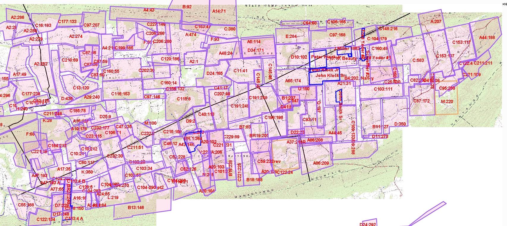
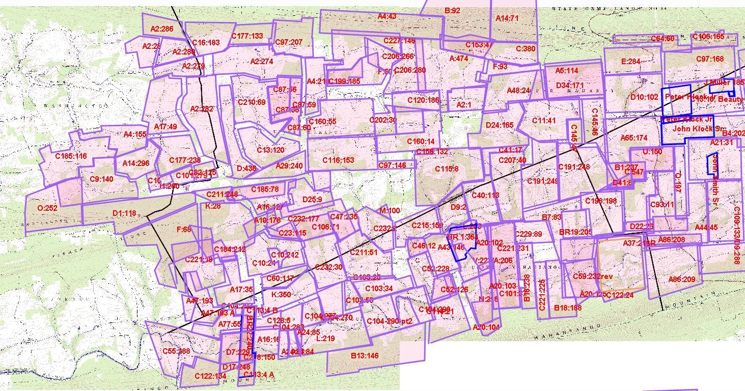
Note that the tract boundaries often do not line up with adjacent surveys (!). The earliest surveys used mainly simple directions (eg, north, south...) and distances (eg, 250 perches). As time went on, they had to be more precise to fill in the gaps. In some cases, the same land shows up in different surveys.
In creating these maps, I noticed that the land was taken up first along the streams. I suppose anyone starting a farm would need water for the farm animals (and drinking and baths...) so this was the first land to be claimed. Second, most of the land was originally sold to distant lawyers, doctors, and merchants in far off places like Philadelphia or even New Jersey who had no intent to actually settle on the land. After they bought the land, it might be sold to closer lawyers and business men residing in Reading, Berks County (since Schuylkill County was part of Berks County until 1811.) After a while, the land took on more local ownership. By the time that Schuylkill County was formed, most of the good land along the streams had already been acquired. People next found and filled in the gaps. The last land to be claimed was the mountain land, where the gaps were claimed in the middle 1800's.
The survey locations are approximate and in some cases may even be incorrect. There was no way to arrange these surveys to avoid gaps and overlaps. So use caution! It is possible to use Google Earth to see where some of the modern lines between fields show where the boundaries likely settled, but building a map showing the ultimate boundaries was beyond the scope of my interest and time (ask if you want the KML file).
Upper Mahantongo, Eldred and Upper Mahanoy Spreadsheet Data
Here is a spreadsheet with a the supporting information used to create this map. Following is the column decoder:
- Index - Used to sort the rows by the order that I entered them.
- Warrant # - Number used in the County Warrant Register to find additional information. Use the first letter of the last name, and then the year, then look for this number to find the information fast.
- County - County where the warrant was taken out.
- W Name - Surname and first name of person taking out warrant.
- W Date - Warrant date.
- R Date - Date survey was returned.
- Acres - acreage returned with survey (sometimes the numbers from the warrant index differ from the survey)
- P Name - Name of person who finally patented the land
- Survey - name of survey (this is what is shown on the map
- Mapped - x=mapped, u=created but no location found, - means skipped as not useful, blank means not mapped
- Notes - my notes on location, etc. M=Mahantongo, LM=Little Mahantongo
- Names - names, mostly of neighbors, shown on the survey. I abbreviated these, so check the original survey for details.
- Adjacent - these are survey numbers that someone at the PA Archives noted on the survey. In most cases, I found these to be correct.
Note that my map overlay did not have western Upper Mahantongo Township, so some of those were not mapped. Always check the original surveys as they often show approximate locations of streams, boundaries with neighbors, dates, etc.
How to use this
In subsequent county deeds, you will often find a reference to the original patent. Unfortunately, it won't give you the survey name. The later deed may give the patent book, date, tract name, or some other clue. You may need to use the other indices at the PA Archive links to convert the patent information into the county warrant and survey shown above. Since I have some of the patent information in the attached spreadsheet, you may be able search that. If this patent information is not shown in the deed, you may need to trace back to earlier deeds (ie, find the deed when the seller originally bought the land). When you hit a brick wall (like a Sheriff's sale with no further info), you might need to trace back the neighbor's land to find earlier references.